


This is the questions that Mr. Fakhzan ask for answer it.
Who built Angkor Wat?
Angkor Wat was built by King Suryavarman II in the 12th century as a vast funerary temple that would hold his remains, symbolically confirming his permanent identity with Vishnu.
Angkor Wat mean?
Angkor Wat (or Angkor Vat)is a temple complex at Angkor, Cambodia, built for the king Suryavarman II in the early 12th century as his state temple and capital city. As the best-preserved temple at the site, it is the only one to have remained a significant religious centre since its foundation—first Hindu, dedicated to Vishnu, then Buddhist. The temple is the epitome of the high classical style of Khmer architecture. It has become a symbol of Cambodia, appearing on its national flag, and it is the country's prime attraction for visitors.
Angkor Wat combines two basic plans of Khmer temple architecture: the temple mountain and the later galleried temple, based on early South Indian Hindu architecture, with key features such as the Jagati. It is designed to represent Mount Meru, home of the devas in Hindu mythology: within a moat and an outer wall 3.6 kilometres (2.2 mi) long are three rectangular galleries, each raised above the next. At the centre of the temple stands a quincunx of towers. Unlike most Angkorian temples, Angkor Wat is oriented to the west; scholars are divided as to the significance of this. The temple is admired for the grandeur and harmony of the architecture, its extensive bas-reliefs and for the numerous devatas (guardian spirits) adorning its walls.
The modern name, Angkor Wat, means "City Temple": Angkor is a vernacular form of the word nokor which comes from the Sanskrit word nagara meaning capital.Prior to this time the temple was known as Preah Pisnulok, after the posthumous title of its founder, Suryavarman II.[1]
What is the Bayon?
The Bayon, located in the geographical heart of Angkor Thom, is the fifty- four-tower
temple and is a quite remarkable sight. Initially the temple seems to be a shapeless
mass of grey and brown stone.
what contributed to the fall of Angkor Wat?
1) Introduction of Theravada Buddhism
The pillar of the Angkor Civilization was supported by the religious belief of Hinduism and Mahayana Buddhism. The monarchs being regarded as the god-king were able to motivate the dedication of their people to serve the throne as a divine service. The empire's extensive irrigation system and military troops required massive laborers and manpower to maintain. The introduction of Theravada Buddhism in 13th century to the Khmers had turned out to hurt sublimely the basic foundation of the Angkor Empire in the long run. Theravada Buddhism taught the people to seek self-enlightenment, abandon worldly things and discourage any superstition belief which directly or indirectly means all deities and all evils. The sovereignty of the Angkorian monarch as a "god-king" or deva-raja was basically challenged.
2) Loss of Water Control
Less devotion of the people to the "god-king" led negative impact to the empire. The Khmers seem unwilling to work wholeheartedly for the king as a holy service as they had previously did. The formerly efficient irrigation and drainage system became silted up with less water supply and the rice crops, used to be cultivated two or three times a year, were dramatically dropped, thus weaken the productivity and the strength of the Angkor Empire.
3) External Threats
As neighboring states of the Angkor grew, they became a major threat to the empire, especially the Thai State of Ayuthaya in the Chaophaya River Basin to the West. In order to protect the empire, the Angkor had to direct portion of its manpower to secure strong armed forces, which in turn, deprived itself from giving good maintenance to its irrigation system.
4) Double-edged sword of Roads Network
The road network built by Jayavarman VII had aided the transports of products and trades throughout the empire and also facilitated the Khmer troops to quell its neighbors. It had became a double-edged sword when the Angkor became weak as the invaders could easily marched in through this road network, instead of previously sailing up from the Mekong River. This turned out to be true when the newly emerged Ayuthaya, a Thai kingdom in the West became stronger. They use this road to march from the Chaophaya River basin through Phnomrung (in Burirum of modern Thailand) and then through Aranyapathet to attack right at the heart of Angkor and finally sacked the empire in 1431. The glory of the Angkor Civilization was terminated since that time.
Who were the Khmer Enemies?
The Siamese
Monday, October 12, 2009
Angkor Wat
Saturday, October 10, 2009
CITY OF JEDDAH,SAUDI ARABIA
...LOCATION...
 Location of Jeddah
...HISTORY...
~Region's Old History~
Jeddah is one of the oldest cities in the Old History. It was known since about 2500 year, so it is an old city which the Old History mentioned that it was meadows for the nineteenth grandfather of the God's Prophet (Kada'aa), which was inhabited by Kada'aa People after the collapse of Maareb Dam in 1115 BC. And it was said that Thamoud People lived in Jeddah before Kada'aa for there was found a Thamoudian engraving in Bouweib Valley to the north eastern of Jeddah. And it goes back to before Alexander The Great who visited it between 323 and 356 BC according to some telling.
~Region's History after Islam~
Islam was brought to Jeddah in the era of the God's Prophet; and during the beginning of the Islamic State, Successor Othman Bin Affan wanted to have access to the sea for its commerce so he chose Jeddah for this purpose in 26 HIJRI 646 AD.
Jeddah continued under the influence of the continuous Islamic succession starting with the Ommiad State reaching Egypt Kings. And Jeddah fence were built by Sultan Kansouh El Ghouri in (915 HIJRI - 1509 AD), who was the last of the Seljuks Kings who ruled Jeddah in the tenth HIJRI century, and in that date the reign was shifted from Egypt Kings to Ottoman State and ended with the siege of King Abed El Aziz Al Suoud for Jeddah City where it was surrendered after signing the surrender agreement between King Abed El Aziz Al Suoud and Sheriff Ali Bin El Hussein in year 1344 HIJRI - 1925 AD. As the political stability took place under the reign of the Saudi Rule under the guidance of King Abed El Aziz Al Suoud (mercy be upon his soul),ah entered a new stage of development and prosperity.
~Modern History~
After uniting the Saudi Arabia Kingdom in (1351 HIJRI, 1932 AD), Jeddah entered a new chronological period which is related to the oil discovery and extracting in (1359 HIJRI, 1938 AD) in the Eastern Region of the Kingdom. And due to its strategic location, it was influenced with the new development means, where modern buildings and giant constructions were built, as well as projects of transportation, telecommunication, and health, and the infra structure and the public utilities started largely during the last decades; so Jeddah features changed from a small and simple city to a big city following the Renaissance and Development Age with the Kingdom's remaining cities.
...GEOGRAPHY... Most of the land in Saudi Arabia is covered with desert. It's central region consist of an eroded plateau, mostly arid and hot in the summer and cold in the winter. The western region is mountaimountainous, except for the coastal plain bordering the Red Sea such as the Jeddah area.
 Jeddah borders the Red Sea from the west and the Al-Sarawat Mountains from the east. It has no rivers or valley but it includes Sharm Ob'hur which connect the Red Sea to the other end of the city. Sharm of Salman borders the city from north.
...ECONOMY...
Jeddah happens to be the second commercial capital of Saudi Arabia and also defined as the second commercial centre of the Middle East after Riyadh. Plus, it's geographical location places it at the heart of the region covered by the Middle East and North Africa. Other than that, Jeddah industrial district is the four largest industrial city in Saudi Arabia after Riyadh, Jubail and Yanbu.
King Abdullah Street is an important place for companies' offices and commercial developments. The street hosts some of the most powerful conglomerates in Saudi Arabia such as Emaar Middle East. Due to the economic boom in this region there is a central business district planned which would be one of the biggest CBD in the eastern world.

While, Tahlia Street is an important fashion and shopping street in the mid-town of Jeddah. It contains many upscale department shops, and boutiques such as Prada, Gucci and Chanel.


...DEMOGRAPHICS...
 Popular Saudi and foreign opinion regards Jeddah as the most liberal and cosmopolitan of Saudi cities due to its historic role as port and gateway to the holy city of Mecca. For over one thousand years, Jeddah has received millions of pilgrims of different ethnicities and backgrounds, from Africa, Central Asia, Southeast Asia, Europe and the Middle East, many of whom remained and became residents of the city. As a result, Jeddah is much more ethnically diverse than most Saudi cities and its culture more eclectic in nature (in contrast with the more geographically isolated, and religiously strict capital Riyadh). Added to the traditional diversity, the oil-boom of the past 50 years has brought hundreds of thousands of working immigrants and fforeign workersfrom non-Muslim countries, the majority originating from continents such as North America (United States of America), Europe (Western Europe), and Asia (South and South-East Asia); there are also many Christian Arabs from the Middle East, coming from Lebanon, Syria, Egypt, and the West Bank and Gaza.
...CITYSCAPE...
~Old Jeddah~
 The Old City with its traditional multistory buildings and merchant houses has lost ground to more modern development. However, the city's recent generations have come to acceptance with the "face of the past". The Old city now helps in shaping the identity of the Saudi Culture, also showing its consuervative development to becoming a modern society, while preserving such areas as the distinict Gabil Market (Gabil Street) and Naseef House and other traditional landmarks.
The Old City is an attraction to non-Saudis who visit Jeddah on terms of Business (Saudi issues visit visas for business, and religious purposes only). In Eid holidays, locals visit the area for traditional style carnivals aimed for families and children.
~Open-air Art..Landmarks~
During the oil boom in the late 1970s and 1980s, there was a focused civic effort at bringing art to Jeddah'spublic areas. As a result, Jeddah contains a large number of modern open air sculptures and works of art, typically situated in roundabouts, which makes it to this day the largest open-air art gallery in the world. Sculptures include works by a variety of artists, ranging from the obscure to international stars such as Alexander Calder,Henry Moore and Victor Vasarely and often depict elements of traditional Saudi culture - coffee pots, incense burners, palm trees, etc. The fact that Islamic tradition prohibits the depiction of living creatures, notably the human form, has made for some very creative modern art, ranging from the tasteful to the bizarre and downright hideous. These include a mounted defunct propeller plane, a giant geometry set, a giant bicycle, and a huge block of concrete with several cars protruding out of it at odd angles.
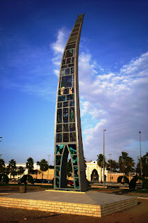
Landmark 1
 Landmark 2
 Unique Landmark 3
Other than that, King Fahd's Fountain is also the cityscape of Jeddah. In Jeddah, there are a few towers that were built for it's developement such as the IDB Tower and Jeddah Municipality Tower.
 King Fahd Fountain
...EDUCATION...
As a well-developed city, Jeddah also pay much attention to the education level of the public including male and female. There are also some international schools built in Jeddah. For higher education, the city has several universities and colleges such as the KingAbdulaziz University and Dar Al-Hekma College.
...TRANSPORT...
Jeddah is served by King Abdulaziz International Airport which is one of the world's busiest airport.The airport has four passenger terminals. One is the Hajj Terminal, a special outdoor terminal covered by very huge tents, which was constructed to handle the more than 2 million pilgrims who pass through the airport during the Hajj season. The Southern Terminal is used for Saudi Airlines flights with the Northern Terminal for foreign and other national airlines. The Royal Terminal is a special terminal for VIPs, foreign Kings and Presidents, and even the Saudi Royal Family. A portion of the airport was used by Coalition B-52 heavy bombers during Operation Desert Storm in 1991.
Moreover,the Jeddah Seaport which is the 32nd busiest seaport in the world (2007) handles the majority of Saudi Arabia's commercial movement.
On top of that, Jeddah does not have any rapid transit system but a current plan to connect the city to the capital, Riyadh, via a train. It is now under construction. The Haramain High Speed Rail Project will provide a high speed rail connection to Mecca and Medina.Modern streets connect the city parts to each other. In Jeddah the main highways run parallel to each other with an eight lane road.
I think all the above information will be enough to show that Jeddah is one of the World's Megacity although maybe it is not as tourism-famous as New York City or Tokyo or even Seoul. I had the opportunity to go there once and I am hoping to go there again. The first night when me and my family arrived at Jeddah, I was amazed by the scenery. The city is glooming with lights and somehow it shows as like the city never sleep (not only Las Vegas does not sleep..). It will be more beautiful if you are seating in a night flight and when you look down out the mirror. Although the weather is hot there but it is not as sticky-sweat we have in Malaysia as the air is dry there in Saudi Arabia..(you won't smell bad eventhough you sweat a lot..). Before I end, here are some more pictures of Jeddah.


OrAtOR


Monday, September 14, 2009
...::\(^_^)/::......::SYAWAL AROUND THE CORNER::...

Aaahh,finally...we are now at the end of the Holy Month for Muslims,Ramadhan...a bit sad that Ramadhan is going to end..we are not sure that we are going to meet again with Ramadhan next year...but then,we are very close to our 'winning day'..Syawal is just around the corner!!!
So here,i want to wish my brothers and sisters of Islam..Happy Celebrating Eid Fitr...!!Maaf Zahir Batin...for those who went home for Raya..send my regards to your family...and to those who are not..La Tahzan~(don't be sad)...every each even simplest thing that happens to us may bring good to us..ada hikmah di sebaliknya..don't forget to pray for our dear family members who have passed away..and go visit them if possible before performing the Solah as some say,their ahzab will starts again right after Solah...May Allah grand them with mercy...Amiin...
And so...SELAMAT HARI RAYA,EVERYONE!!for those who are flying home..i pray you safely depart and arrive home...BON VOYAGE~~~

Friday, September 11, 2009
iNdIan ClaSsiCal iNsTrUmEnT: VEENAI


The veenai is one of the most ancient string instruments of India. It is almost similar to the Grecian harp. There are three types of veenai; saraswati veenai, rudra veenai and vichitra veenai. The highest quality veenai have the whole body
carved from a single block of wood, while the lower quality veenai is carved in three sections (the resonator,neck and head). Commonly, veenai has a large, round body with a thick, wide neck, the end of which is carved into the head of a dragon. A small resonator is attached to the underside of the neck. The veenai has 24 metal frets embedded in hardened Beeswax, mixed with charcoal powder. Melody is produced on four metal strings that run above the frets. These are stretched over a wide bridge that sits on the body of the veenai. Three other strings run alongside the neck of the instrument. These are used for maintaining time and for playing the drone. The performer, who sits cross-legged on the stage, rests the small resonator on the left lap. The fingers of the left hand are used to press, pull and glide on the frets, while the fingers of the right hand are used to pluck the strings. The saraswati veenai is made up of jackwood, 52" long, has 24 brass frets and 7 strings.Unlike north Indian instruments like the sitar, the Saraswati veenai has no sympathetic strings. It has only four playing strings and three drone strings (thalam). A major centre for the manufacture of the Saraswati veenai is in Thanjavur. The rudra veenai is also known as the been. The duration of these veenai's notes is incredibly long. The been is made of a body, a hollow tube made of teak wood, on which the strings are fixed at both ends. The bridge is a flat bridge, multiplying the depth of the note's wavelength. Veenai is an integral part of the rich Carnatic music in Thanjavur. Popularly known as Veena, Veenai bears relics to the rich religious and cultural history of the place. According to mythological legends, Goddess Saraswati is always seen to play musical instrument of veenai.
Tuesday, September 8, 2009
hohohoh

selamat hari raya to all muslims and hopefully u all get blessed.... mintak mak kuih sepotong... saya mahu makan dengan perut kosong.......
The indigenous peaple in amazons-indian


Indigenous people
Sawaddikap….. This week I want to talk about the indigenous people. As we know… these people are very unique and have mystic customs. Hum… for sure I will let you know about the indigenous people lived in Amazon-Indians.
Who are indigenous people?
The indigenous people can be describe any ethnic group of people who inhibit a geographic region with which they have the earliest known historical
 connection, alongside the more resents immigrants who have populated the region and may be greater in number.
The indigenous people in Amazon
As we know…... rainforest are bursting with life. There are many and many types of species of plants and animal live in rainforest, but not only that… people also live in the rainforest as their home…. Besides that, indigenous or native have lived in there for long times ago. . Many of these original peoples, such as the Cribs (after whom the Caribbean Sea is named) have disappeared completely. Others are only scattered remnants of what they once were. Various indigenous people of the Amazon are represented, including the Matis, Matsés-Mayoruna, Huaorani, Bora, Shipibos, Yagua, Marubo, Ticuna, Kayapó, Suyá, and Xingu Amazonian native tribes. Various ceremonies and rituals are illustrated, most importantly the Ceremony of Mariwin, Matsés-Mayoruna Poison Frog Ceremony, Dance of Queixada, Ritual of Capybara, Ticuna Indian Girl Puberty Rite of Passage, Marubo Ceremony of Aco, and the Kuarup (Kwarup) Ceremony of the Dead. Amazon is covered, as well as hunting with blowguns and curare.
In my questions, how do their lived? Ho3… let me answer that….
Although some indigenous people live
 much as we do, others still live much as did their ancestors thousands of years before them. These communities organize their daily lives differently than our culture. Their food, medicines and clothing come primarily from the forest. Besides hunting, gathering wild foods and fishing, the indigenous people also plant small gardens for the other sources of foods. They used method called shifting cultivation to plant their crops. Let me explain further about the shifting method.... first they clear a small area of land and burn it, and then they plant their crops to be used for food and medicines. After a few years later, the soil has become too poor to allow for more crops to grow and they move to a nearby unclear area. This land traditionally allowed regrowing for 10-50 years before it is farmed again. How the indigenous people doing to save their territory? Indigenous groups are beginning to fight for their land, most often through peaceful demonstrations. Such actions may cause them to be arrested or even to lose their lives, but they know that if they take no action, their land and culture could be lost forever.